NASA's ECOSTRESS set to correct agricultural water imbalances
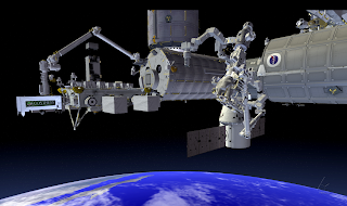
NASA plans to install ECOSTRESS on the International Space Station (ISS) that will measure the temperature of plants from space, enabling researchers to determine plant water use and to study how drought conditions affect plant health.
ECOsystem Spaceborne Thermal Radiometre Experiment on Space Station, or ECOSTRESS will hitch a ride to the space station on a SpaceX cargo resupply mission scheduled to launch from Cape Canaveral Air Force Station in Florida on June 29, NASA said on Tuesday. ECOSTRESS is one of two instruments selected in July for NASA's Earth Venture-Instrument series of missions. These missions are part of the Earth System Science Pathfinder program, managed by NASA's Langley Research Center in Hampton, Virginia, for NASA's Science Mission Directorate.
The water is released through pores on the plants’ leaves through a process called transpiration. If there is not enough water available to the plants, they close their pores to conserve water, causing their temperatures to rise. Plants use those same pores to take up carbon dioxide from the atmosphere for photosynthesis If they continue to experience insufficient water availability, or “water stress,” they eventually starve or overheat, and die. By looking at ECOSTRESS imagery of a certain location over the course of days to weeks, scientists will be able to see how evapotranspiration varies in that location throughout the day. This is important, because plants that get enough water in the cool of the morning might shut down in afternoon heat.
As told by Simon Hook, ECOSTRESS principal investigator at NASA’s Jet Propulsion Laboratory in Pasadena, California, “Measuring the temperature of the plant lets you see that a plant is stressed because recovery at this stage is often too late”.
Existing satellite instruments that monitor evapotranspiration offer either high spatial resolution but low time frequency (a couple of measurements a month), or high time frequency and coarse spatial resolution (1,600 feet, or 500 meters square). Scientists, farmers and water managers need both high resolution and high frequency. ECOSTRESS will provide a four-day repeat cycle and a spatial resolution of 125 feet (38 meters) by 185 feet (57 meters), high enough to see most farms and small differences within ecosystems.
"We are keeping an eye on how ECOSTRESS can be applied not only to science but society at large," said Andy French, a U.S. Department of Agriculture scientist and member of the mission's team. "It could be very useful for water managers and farmers." By combining the instrument's measurements with other ecosystem data, scientists will be able to calculate how efficiently plants use water to process carbon dioxide and identify plants likely to be more resilient during droughts.The mission will target regions where models disagree about water use efficiency, and ECOSTRESS data will be used to improve those models.


Comments
Post a Comment